 I’m at the BSI again. It’s 4.45pm and I’m waiting for the bus to Skogar. It’s been hot and sunny today in Reykjavik, making wandering around the familiar streets even more of a pleasure: it’s a lovely, friendly city that looks so much lovelier in sunshine, like everywhere. But Iceland in the summer has the advantage, on days such as these, of 23 hours of sunshine, broken only by an hour of dusk. It takes some of the urgency out of walking.
I have made myself known to Leifur, the Utivist guide, who has assured me that the bus will arrive soon. But, frankly, sitting in the sunshine, I am in no hurry. But I am nervous again: it is the same anxiety as the last time I waited here with my back pack, before walking the Laugavegurinn, wondering with whom I’ll be spending the next few days…
***
So there are 8 of us, including Leifur the guide: four Icelandic women, a Canadian, and an Icelandic man (without a raincoat, something he may yet regret). We’ve stopped at a service station (so much of this country revolves around its service stations…) for the obligatory coffee stop after rolling through the flat farmland of the southern coastal plain: Hveragerdi and Sellfoss are behind us and the Westman Islands are off in the distance. After the day’s sunshine, the sky has closed in with heavy grey cloud.
I chat with Leifur while he eats an ice cream. He is an air traffic-controller by profession, and guiding for Utivist is a hobby. I mention that I had walked the Laugavegurinn a couple of years before and ever since had wanted to finish it off with this walk. He looks disappointed, then concedes that, maybe, for foreigners, yes; but for an Icelander, these were considered completely separate walks. For a start, an Icelander would always walk south from Landmannalaugur, and north from Skogar (for better views of the waterfalls on the way up), ending both routes in Thorsmork. That they end in the same place does not make them the same walk. I feel chastened.
Onwards, and after a quick stop at Seljalandsfoss, we roll into – for me – new territory and into heavy rain. We are nearing Skogar and the prospect of starting out very wet is a real one. I run a mental stock-take of my waterproofs.
The steep slopes of the mountains we are to cross are closer now, and the strip of coastal plain narrower. The shore is not too distant and, under the slate sky, it is suddenly claustrophobic, despite the vibrant green of the grass and the clumps of yellow flowers that populate it. The near hills are craggier, the higher ones wreathed in cloud. Another river weaves through its broad shale bed and my nervous anticipation is twitching through my head, my shoulders. We are soon for the off.
***
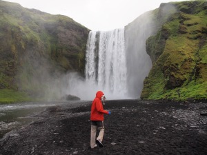
 We set off from Skogar in the rain, climbing a steep path alongside Skogafoss, at around 8pm. We followed the ravine that feeds the falls, walking trough green Icelandic hills. Countless, striking waterfalls, twenty or more, most of which Leifur could name, indicated the gradient of our ascent. Most of the time it was a fairly steady and even climb, punctuated with the occasional steep section. There was one terrifying scramble along a goat track (to be fair, there were no goats, just confused sheep): the path became simply a faint series of ledges inside the lip of the ravine. No-one paid much attention to the stunning cascade (name unknown) that thundered down across the ravine as we picked our way along.
Somewhere around this time, the vegetation gave way to black ash – a relic of the 2010 eruption – and the sky cleared sufficiently to reveal the top of the offending volcano under its ice cap. The terrain became black and white. On some of the last grass, we stopped by the bridge across the river to eat, rest and refresh our water bottles from the rushing water. We had already had the hut pointed out to us, a small square up on a distant ridge. But this was a cruel hope, as we were still some three hours out.
We crossed the footbridge – I had been dreading the prospect of wading the river ever since it had become clear that we were on the wrong side of it, and had been very pleased to see the bridge: I was wet enough already with the rain – and set off on a new path. The sprinkling of ash became a blanket, covering the remaining moss and the ice banks that should have been snow, making walking springy but tiring.
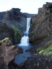
 The path took us past a beautiful fanned waterfall (actually unnamed) before more climbs, more ash and an increasing amount of ice, which was still pebble-dashed with coconut-sized ash bombs from the 2010 eruption. The hut hung tantalisingly close above us on the ridge, but was still an hour away. One last ice field, sloping dangerously into a ghyll; tired legs made it a nervous time. Two of the Icelanders were flagging seriously, but all of us were seriously knackered. We made it up the the final slope to the ridge in time to see the sky pinkening with the almost-dawn.
It is 3am: we set off seven hours ago in the rain and low cloud, and now it is ‘dawn’ (it never got dark) under a clearing sky. The views are great, both back the way we have come and over the ridge to the next stage, but it is too late and I am too knackered to properly enjoy them.
 Others are already sleeping in the hut, and our little group are silently unpacking sleeping bags and whatever else is needed in order to fall into bed and into sleep. I have made my ‘ablutions’ out along the ridge in the chill wind, with what seems like the whole world spread out beneath me. So, it is time to fold myself into my sleeping bag, and take what rest I can before today begins again.
A more complete set of photos is here


